The following questions are a direct excerpt from the test bank the FAA uses for the Instrument Pilot Airplane Knowledge Test. Remember to choose the BEST answer you can. Take the time to make handwritten notes of each question(s) you are unsure of or are marked incorrect during this quiz. You will need an 85% or better to pass this quiz.
Keep in mind you may screenshot questions (screenshot the whole page with question, figure, and answers) you do not understand, and email the screenshot to us at cfi@fly8ma.com for an explanation from one of our CFII’s.
Also keep in mind you can rewatch the videos in the lessons, and adjust the playback speed of the videos to slow them down or speed them up.
Good luck with the quiz! You have 35 minutes to complete it.
You can access the FAA’s Computer Test Supplement with all of the figures here.
IFR Flights
Quiz Summary
0 of 60 Questions completed
Questions:
Information
You have already completed the quiz before. Hence you can not start it again.
Quiz is loading…
You must sign in or sign up to start the quiz.
You must first complete the following:
Results
Results
0 of 60 Questions answered correctly
Your time:
Time has elapsed
You have reached 0 of 0 point(s), (0)
Earned Point(s): 0 of 0, (0)
0 Essay(s) Pending (Possible Point(s): 0)
| Average score |
|
| Your score |
|
Categories
- Not categorized 0%
| Pos. | Name | Entered on | Points | Result |
|---|---|---|---|---|
| Table is loading | ||||
| No data available | ||||
- 1
- 2
- 3
- 4
- 5
- 6
- 7
- 8
- 9
- 10
- 11
- 12
- 13
- 14
- 15
- 16
- 17
- 18
- 19
- 20
- 21
- 22
- 23
- 24
- 25
- 26
- 27
- 28
- 29
- 30
- 31
- 32
- 33
- 34
- 35
- 36
- 37
- 38
- 39
- 40
- 41
- 42
- 43
- 44
- 45
- 46
- 47
- 48
- 49
- 50
- 51
- 52
- 53
- 54
- 55
- 56
- 57
- 58
- 59
- 60
- Current
- Review
- Answered
- Correct
- Incorrect
-
Question 1 of 60
1. Question
Refer to the diagram below. For planning purposes, what would be the highest MEA on V187 between Grand Junction, Walker Airport, and Durango, La Plata Co. Airport?
 CorrectIncorrect
 -
Question 2 of 60
2. Question
Refer to the diagram below. While passing near the CORTEZ VOR, southbound on V187 contact is lost with Denver Center. You should, attempt to reestablish contact with Denver Center on
 CorrectIncorrect
 -
Question 3 of 60
3. Question
Refer to the diagram below. Your original route of flight was CEZ V391 JNC. However, due to thunderstorms en route, ATC revises your route to CEZ V391 DVC V68 MTJ V26 JNC. Calculate how much additional fuel will you consume given the following:
Winds = 230 @ 40 kts
TAS = 130 kts
GPH = 17
 CorrectIncorrect
 -
Question 4 of 60
4. Question
Refer to the diagram below. What is the MOCA between JNC and MANCA intersection on V187?
 CorrectIncorrect
 -
Question 5 of 60
5. Question
Refer to the diagram below. At what point should a VOR changeover be made from JNC VOR to MANCA intersection southbound on V187?
 CorrectIncorrect
 -
Question 6 of 60
6. Question
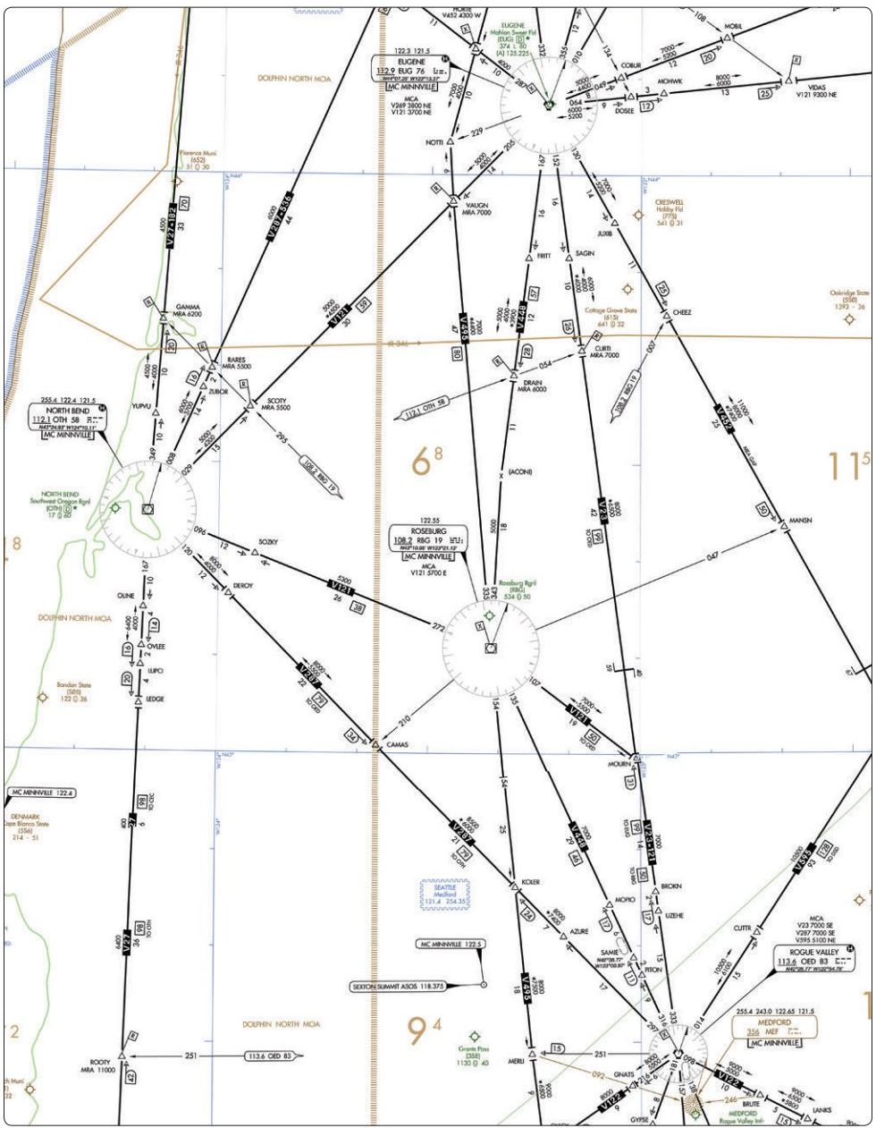
Refer to the diagram below. What minimum navigation equipment is required en route on V448 to identify MOPIO?
 CorrectIncorrect
 -
Question 7 of 60
7. Question
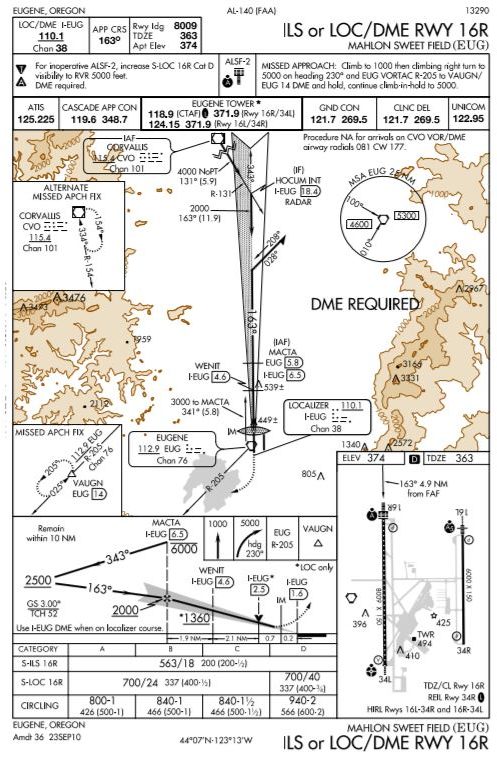
Refer to the diagram below. What is the TDZ elevation for RWY 16R on Eugene/Mahlon Sweet Field?
 CorrectIncorrect
 -
Question 8 of 60
8. Question
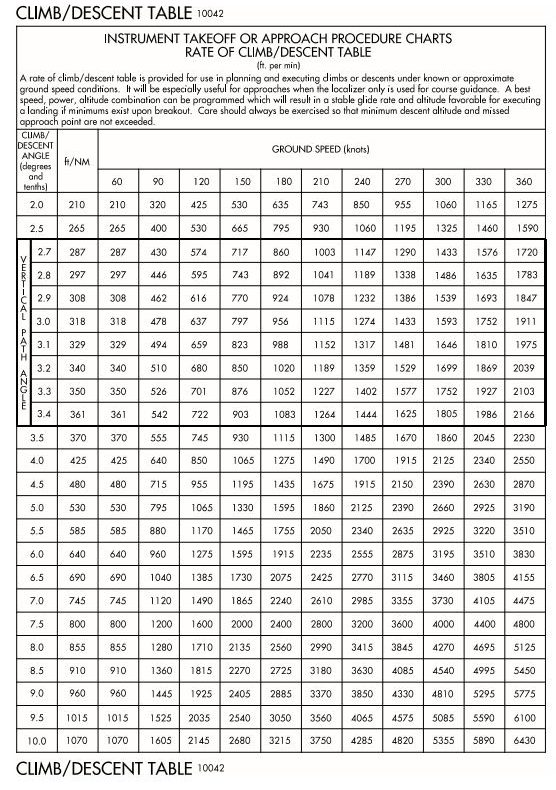
Refer to the diagrams below. Using a groundspeed of 90 knots on the ILS final approach course, what rate of descent should be used as a reference to maintain the ILS glide slope?

 CorrectIncorrect
 -
Question 9 of 60
9. Question
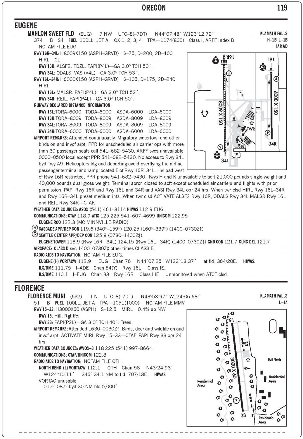
Refer to the diagram below. What are the hours of operation (local standard time) of the control tower at Eugene/Mahlon Sweet Field?
 CorrectIncorrect
 -
Question 10 of 60
10. Question
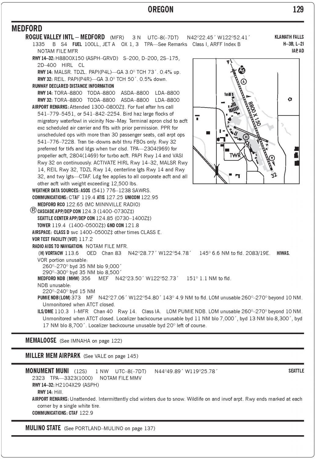
Refer to the diagram below. To which maximum service volume distance from the OED VORTAC should you expect to receive adequate signal coverage for navigation at 8,000 ft.?
 CorrectIncorrect
 -
Question 11 of 60
11. Question
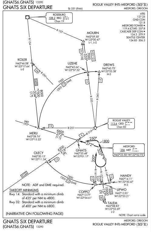
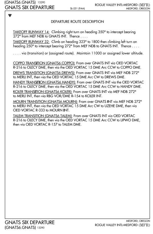
Refer to the diagram below. Which restriction to the use of the OED VORTAC would be applicable to the (GNATS6.MOURN) departure?
 CorrectIncorrect
 -
Question 12 of 60
12. Question
Refer to the diagrams below. Using an average ground speed of 120 knots and taking off on Runway 14, what minimum rate of climb must be maintained to meet the required climb rate (in feet per NM) to 4,800 feet as specified on the instrument departure procedures?
 CorrectIncorrect
 -
Question 13 of 60
13. Question
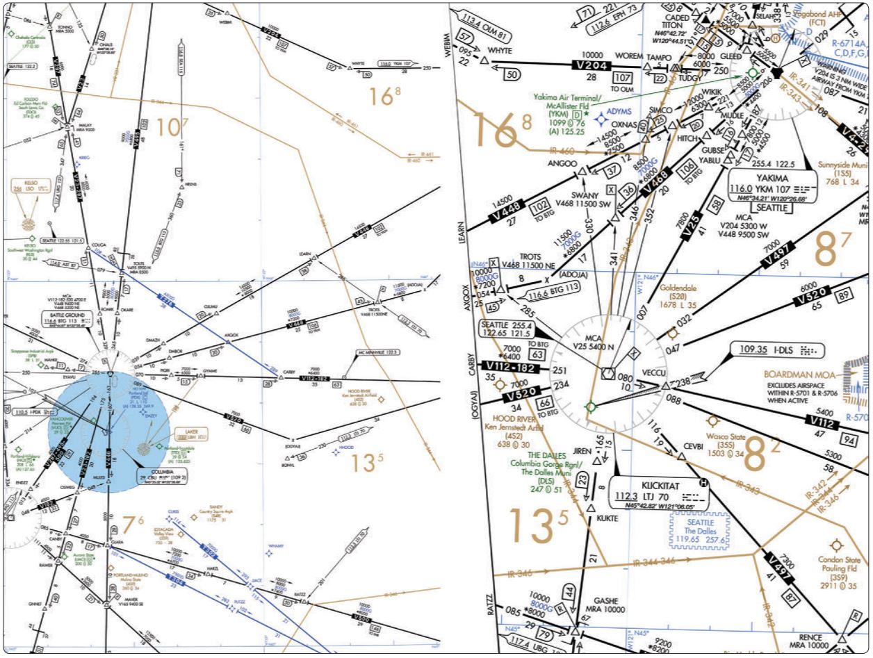
Refer to the diagram below. En route on V112 from BTG VORTAC to LTJ VORTAC, the minimum altitude crossing Gymme intersection is
 CorrectIncorrect
 -
Question 14 of 60
14. Question
Refer to the diagram below. When en route on V448 from YKM VORTAC to BTG VORTAC, what minimum navigation equipment is required to identify ANGOO intersection?
 CorrectIncorrect
 -
Question 15 of 60
15. Question
Refer to the diagram below. En route on V468 from BTG VORTAC to YKM VORTAC, the minimum altitude at TROTS intersection is
 CorrectIncorrect
 -
Question 16 of 60
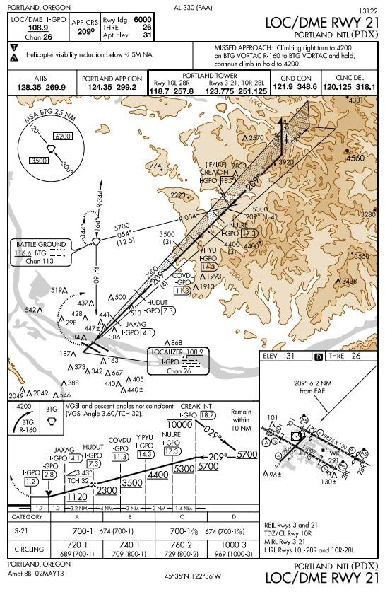
16. Question
Refer to the diagram below What is the MDA and visibility criteria for a straight-in LOC/DME RWY 21 approach at Portland International in a Category B airplane?
 CorrectIncorrect
 -
Question 17 of 60
17. Question
Refer to the diagram below. With a ground speed of 120 knots, approximately what minimum rate of descent will be required between I-GPO 11.3 DME fix (COVDU) and the I-GPO 7.3 DME fix?
 CorrectIncorrect
 -
Question 18 of 60
18. Question
Refer to the diagram below. You have been cleared to the CREAK intersection via the BTG 054° radial at 7,000 ft. Approaching CREAK, you are cleared for the LOC/DME RWY 21 approach to POX. Descent to procedure turn altitude should not begin prior to
 CorrectIncorrect
 -
Question 19 of 60
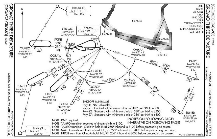
19. Question
Refer to the diagram below. Using an average ground speed of 140 knots, what minimum indicated rate of climb must be maintained to meet the required climb rate (feet per NM) to 6,300 feet as specified on the instrument departure procedure for RWY22?
 CorrectIncorrect
 -
Question 20 of 60
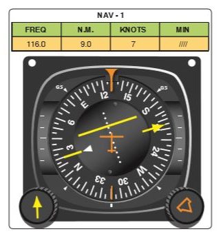
20. Question
Refer to the diagrams below. What is your position relative to the 9 DME ARC and the 206° radial of the instrument departure procedure?
 CorrectIncorrect
 -
Question 21 of 60
21. Question
Refer to the diagram below. With a ground speed of 120 knots, approximately what minimum rate of descent will be required between I-GPO 7.3 DME fix (HUDUT) and the I-GPO 4.1 DME fix?
 CorrectIncorrect
 -
Question 22 of 60
22. Question
Refer to the diagram below. What determines the MAP on the LOC/DME RWY 21 approach at Portland International Airport?
 CorrectIncorrect
 -
Question 23 of 60
23. Question
Refer to the diagram below. When conducting the LOC/DME RWY 21 approach at POX, what is the Minimum Safe Altitude (MSA) while
maneuvering between the BTG VORTAC and CREAK intersection?
 CorrectIncorrect
 -
Question 24 of 60
24. Question
Refer to the diagram below. When conducting a missed approach from the LOC/DME RWY 21 approach at POX, what is the Minimum Safe Altitude(MSA) while maneuvering between the runway and BTG VORTAC?
 CorrectIncorrect
 -
Question 25 of 60
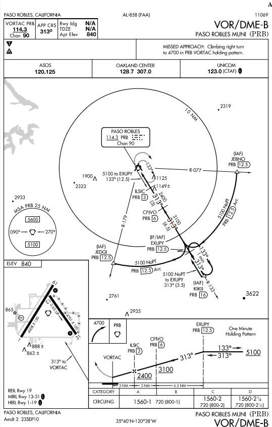
25. Question
Refer to the diagram below. As a guide in making range corrections, how many degrees of relative bearing change should be used for each one half-mile deviation from the desired arc?
 CorrectIncorrect
 -
Question 26 of 60
26. Question
Refer to the diagram below. Under which condition should a missed approach procedure be initiated if the runway environment (Paso Robles Municipal Airport) is not in sight?
 CorrectIncorrect
 -
Question 27 of 60
27. Question
Refer to the diagram below. Using an average ground speed of 100 knots, what minimum rate of climb would meet the required minimum climb rate per NM as specified by the instrument departure procedure?
 CorrectIncorrect
 -
Question 28 of 60
28. Question
Refer to the diagram below. Where is the VOR COP on V27 between the GVO and MQO VORTACs?
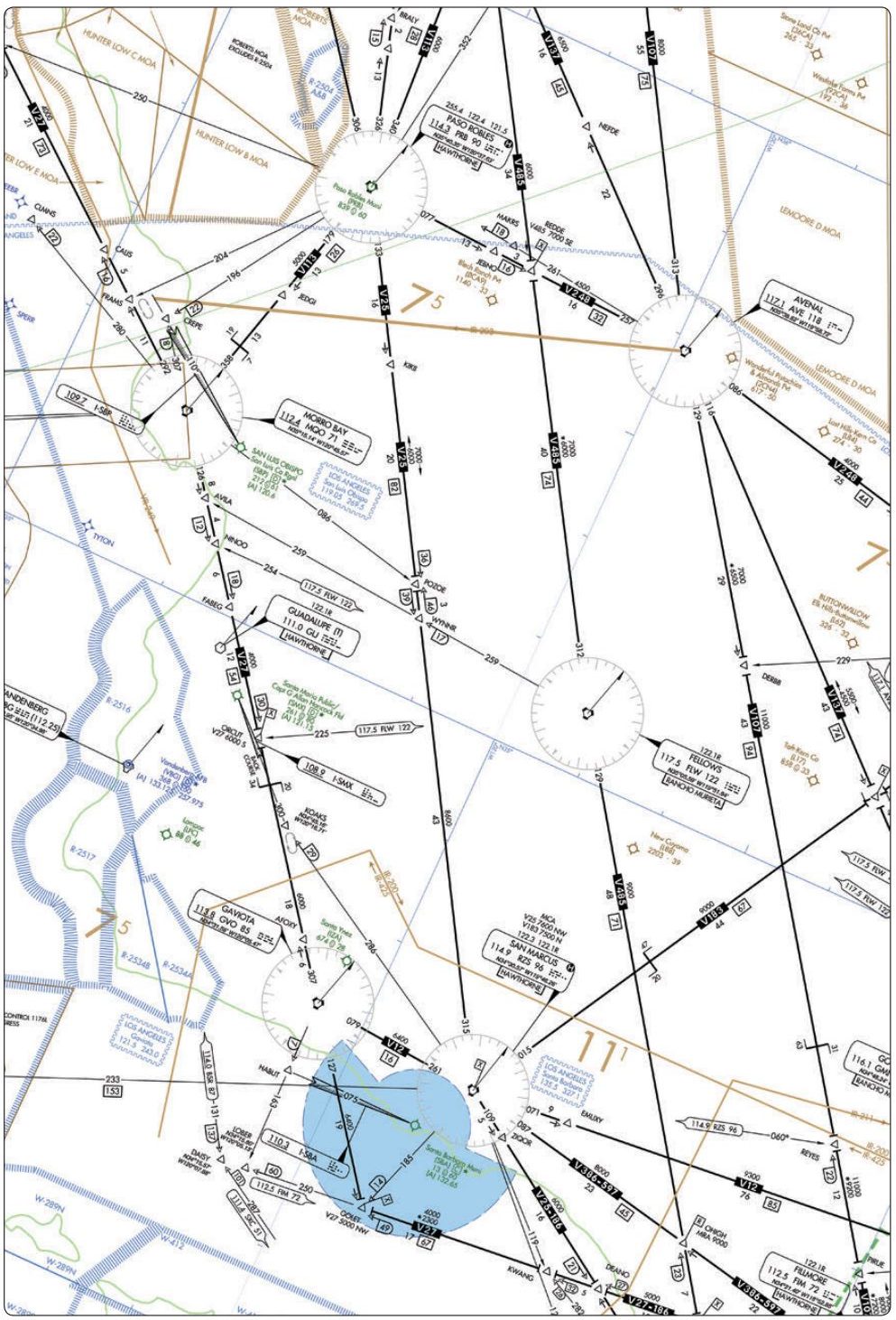 CorrectIncorrect
 -
Question 29 of 60
29. Question
Refer to the diagram below. What is indicated by the inverse “H” symbol in the radio aids to navigation box for SAN MARCUS VORTAC?
 CorrectIncorrect
 -
Question 30 of 60
30. Question
Refer to the diagrams below. Using an average ground speed of
90 knots, what minimum rate of climb would meet the required minimum climb rate per NM as specified by the instrument departure procedure?
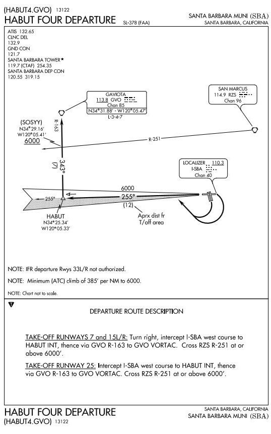
 CorrectIncorrect
 -
Question 31 of 60
31. Question
Refer to the diagram below. Using an average ground speed of 90 knots, what constant rate of descent from 3,100 feet MSL at the 6 DME fix would enable the aircraft to arrive at 2,400 feet MSL at the FAF?
 CorrectIncorrect
 -
Question 32 of 60
32. Question
Refer to the diagram below. For planning purposes, what is the highest usable altitude for an IFR flight on V573 from the HOT VORTAC to the TXK
VORTAC?
 CorrectIncorrect
 -
Question 33 of 60
33. Question
Refer to the diagrams below. At which point does the BYP.BYP6 arrival begin?
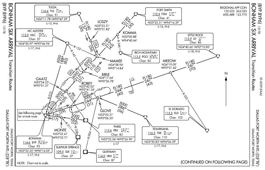
 CorrectIncorrect
 -
Question 34 of 60
34. Question
Refer to the diagram below. Under which condition should the missed approach procedure for the RNAV(GPS) RWY 33 approach be initiated?
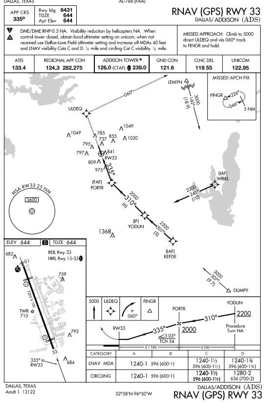 CorrectIncorrect
 -
Question 35 of 60
35. Question
Refer to the diagram below. What is the MDA and visibility criteria respectively for the circling approach procedure?
 CorrectIncorrect
 -
Question 36 of 60
36. Question
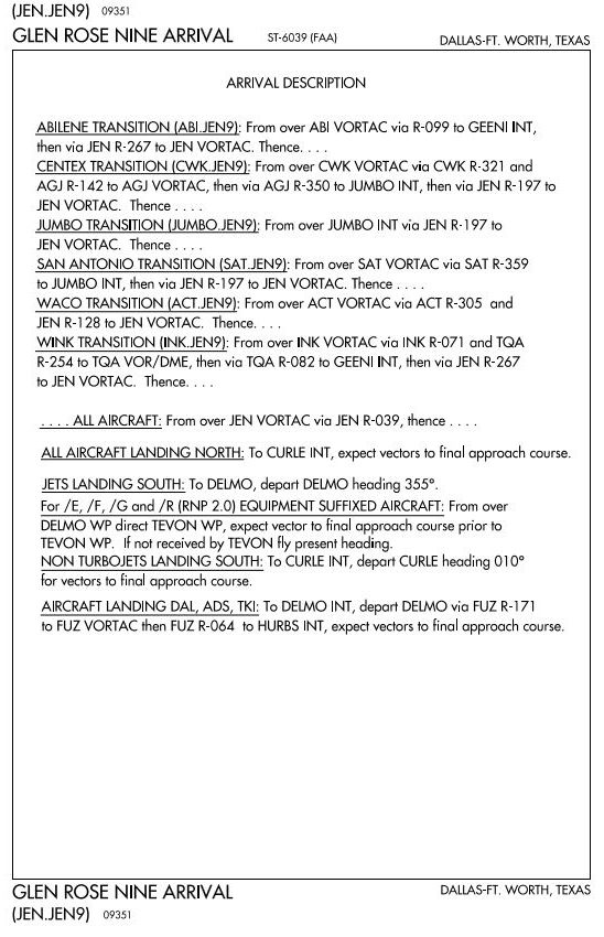
Refer to the diagrams below. When DFW is landing to the north, at CURLE expect
 CorrectIncorrect
 -
Question 37 of 60
37. Question
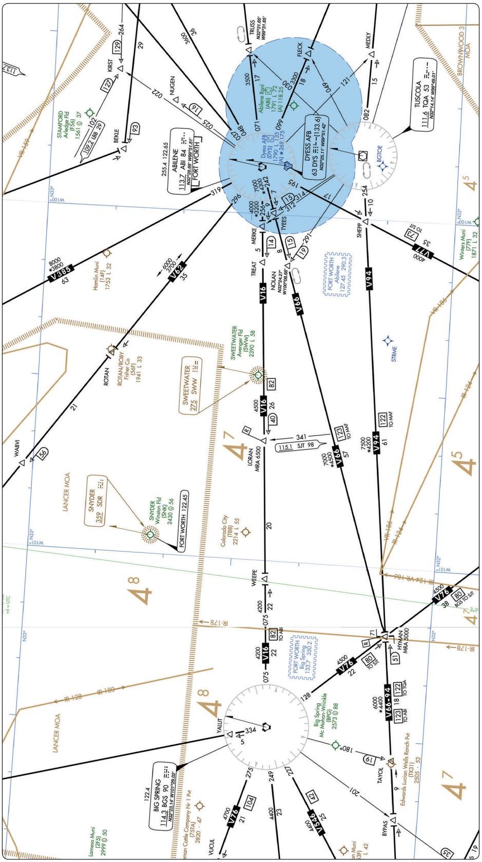
Refer to the diagram below. For planning purposes, what is the highest usable altitude for an IFR flight on V16 from the BGS VORTAC to ABI VORTAC?
 CorrectIncorrect
 -
Question 38 of 60
38. Question
Refer to the diagrams below. At which point does the JEN.JEN9 arrival begin?

 CorrectIncorrect
 -
Question 39 of 60
39. Question
Refer to the diagrams below. Which frequency would you anticipate using to contact Regional Approach Control? (GLEN ROSE NINE ARRIVAL).

 CorrectIncorrect
 -
Question 40 of 60
40. Question
Refer to the diagrams below. On which heading should you plan to depart DELMO intersection?

 CorrectIncorrect
 -
Question 41 of 60
41. Question
Refer to the diagram below. What is the difference in elevation (in feet MSL) between the airport elevation and the THRE for RWY 36L?
 CorrectIncorrect
 -
Question 42 of 60
42. Question
Refer to the diagram below. Which navigational information and services would be available to the pilot when using the localizer frequency?
 CorrectIncorrect
 -
Question 43 of 60
43. Question
Refer to the diagrams below. What rate of descent should you plan to use initially to establish the glidepath for the ILS RWY 36L approach? (Use 120 knots ground speed.)

 CorrectIncorrect
 -
Question 44 of 60
44. Question
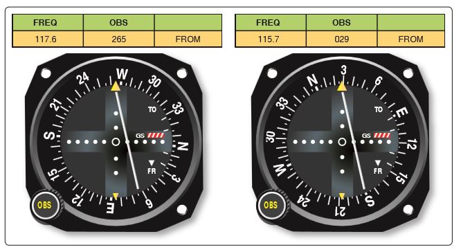
efer to the diagrams below. What is your position relative to the FLOSI intersection northbound on V213 airway?
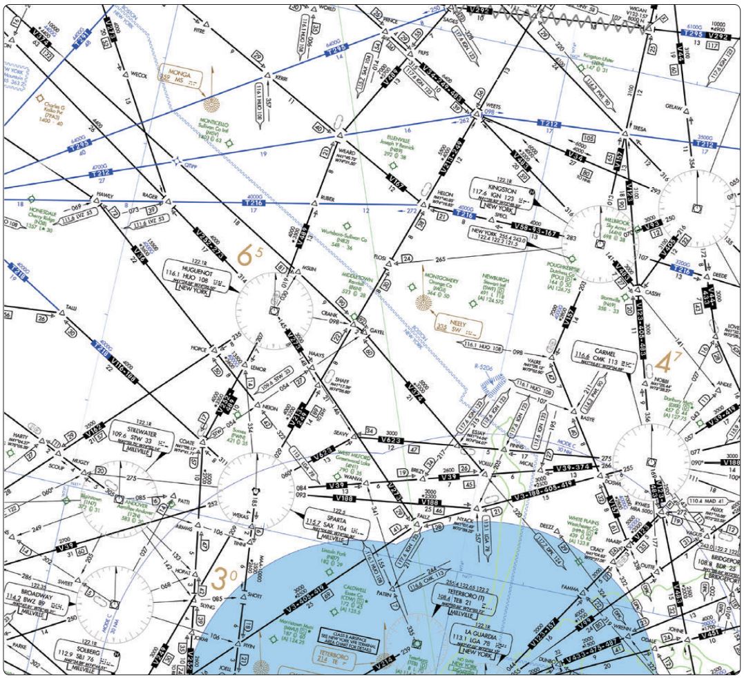 CorrectIncorrect
 -
Question 45 of 60
45. Question
Refer to the diagram below. At which indication or occurrence should you initiate the published missed approach procedure for the ILS RWY 6 approach provided the runway environment is not in sight?
 CorrectIncorrect
 -
Question 46 of 60
46. Question
Refer to the diagram below. What is the minimum altitude at which you should intercept the glide slope on the ILS RWY 6 approach procedure?
 CorrectIncorrect
 -
Question 47 of 60
47. Question
Refer to the diagram below. What is the touchdown zone elevation for RWY 6?
 CorrectIncorrect
 -
Question 48 of 60
48. Question
Refer to the diagrams below. Using an average ground speed of 90 knots on the final approach segment, what rate of descent should be used initially to establish the glidepath for the ILS RWY 6 approach procedure?

 CorrectIncorrect
 -
Question 49 of 60
49. Question
Refer to the diagrams below. Which runway and landing environment lighting is available for approach and landing on RWY6 at Bradley International?

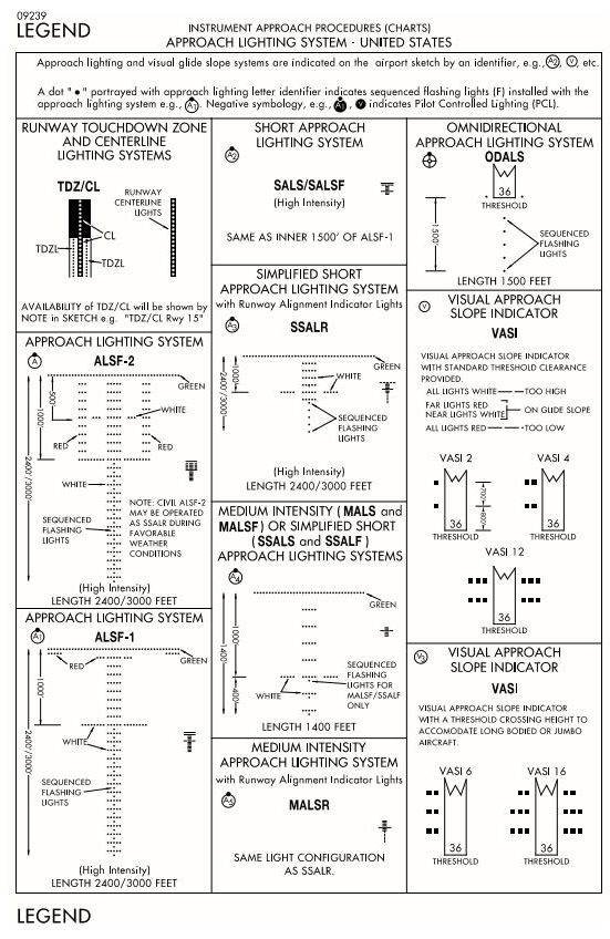 CorrectIncorrect
 -
Question 50 of 60
50. Question
Refer to the diagrams below. After passing the OM, Bradley Approach Control advises you that the MM on the ILS RWY 6 approach is inoperative . Under these circumstances, what adjustments, if any, are required to be made to the DH and visibility?

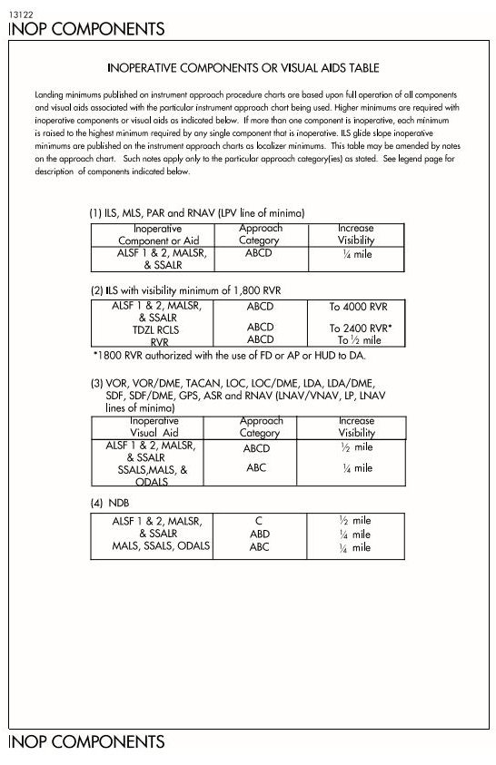 CorrectIncorrect
 -
Question 51 of 60
51. Question
Refer to the diagrams below. At which location or condition does the STELA.STELA1 arrival begin?
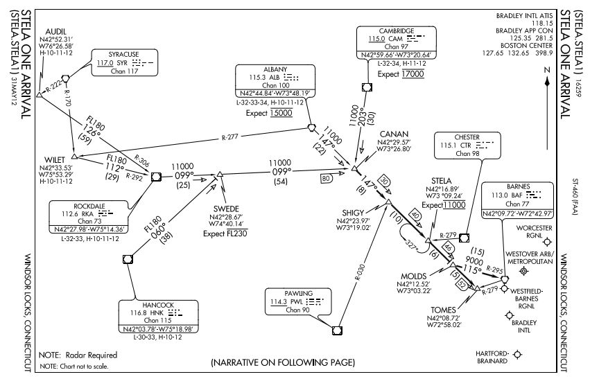
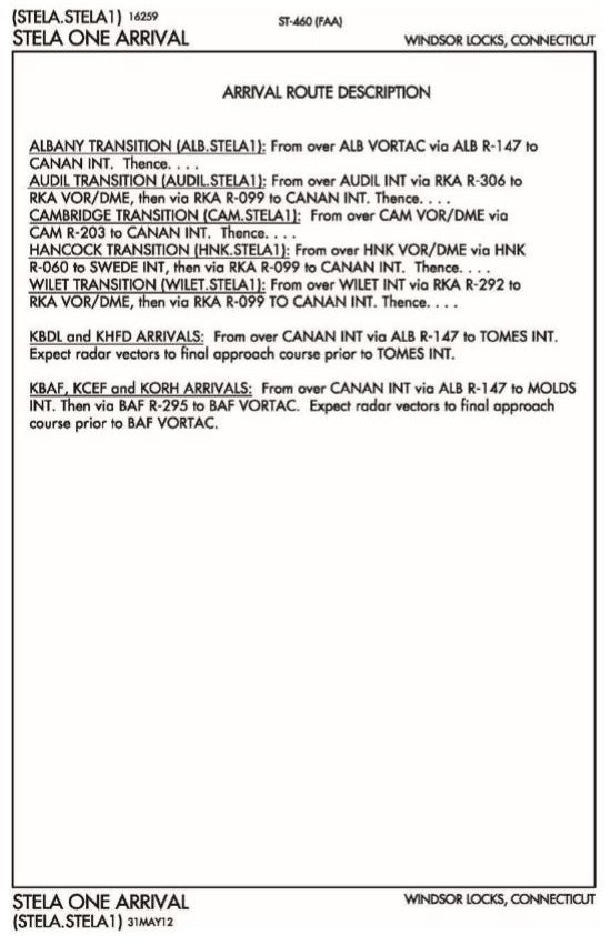 CorrectIncorrect
 -
Question 52 of 60
52. Question
Refer to the diagrams below. Which en route low altitude navigation chart would cover a proposed routing at the BOZEMAN VORTAC?

 CorrectIncorrect
 -
Question 53 of 60
53. Question
Refer to the diagram below. Which en route low altitude navigation chart would cover a proposed routing at the BOZEMAN VORTAC?
 CorrectIncorrect
 -
Question 54 of 60
54. Question
Refer to the diagram below. Using an average ground speed of 140 knots, what minimum rate of climb would meet the required minimum climb rate per NM as specified on the instrument departure procedure from RWY 9?
 CorrectIncorrect
 -
Question 55 of 60
55. Question
Refer to the diagram below. When eastbound on V86 between Whitehall and Livingston, the minimum altitude that you should cross BZN is
 CorrectIncorrect
 -
Question 56 of 60
56. Question
Refer to the diagram below. What is the maximum altitude that you may flight plan an IFR flight on V-86 EASTBOUND between BOZEMAN and BILLINGS VORTACs?
 CorrectIncorrect
 -
Question 57 of 60
57. Question
Refer to the diagram below. What is the minimum crossing altitude over the BOZEMAN VORTAC for a flight southeast bound on V86?
 CorrectIncorrect
 -
Question 58 of 60
58. Question
Refer to the diagram below. At which minimum altitude should you cross the STAKK intersection?
 CorrectIncorrect
 -
Question 59 of 60
59. Question
Refer to the diagram below. Which aircraft approach category should be used for a circling approach for a landing on RWY 28R in an aircraft with a V50 of 72 kt.?
 CorrectIncorrect
 -
Question 60 of 60
60. Question
Refer to the diagram below. How many initial approach fixes serve the VOR/DME RWY 28R (Billings Logan) approach procedure?
 CorrectIncorrect

Responses