
Lesson 15: VFR Charts and Navigation
Charting your path to success! There are many different charts or “maps” pilots use to find their way through the sky. You’ve already had a…
Charting your path to success! There are many different charts or “maps” pilots use to find their way through the sky. You’ve already had a…
Lucky Weather Probably not two things you’ll hear associated much in aviation. Generally, when it comes to weather, Murphy’s Law is in full effect and…
Not as heavy as you might have thought While weight and balance is a very important topic, it’s not as difficult as many pilots make…
Knowledge is Power! Well, knowing about your engine is power anyways. And knowing about your aircraft systems and instruments is even more power! What we’re…
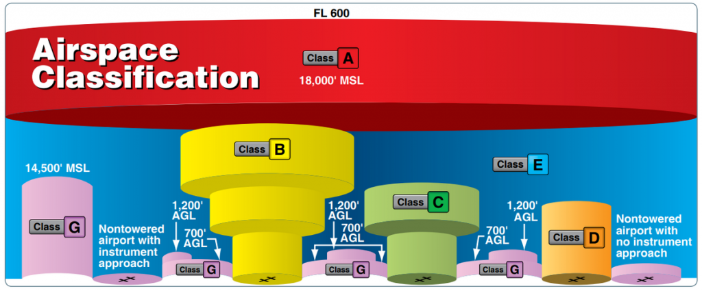
Class A, Class B, and Class C Airspace Class A, B and C airspace are all controlled airspace. Although it is designated as such because…
Class G, E, and D airspace: Luckily whether you have a GED or PHD, you can learn the layout of the different airspace that makes…
Graphic Forecast The GFA has replaced the FA for the lower 48 United States. Watch the video above on how to use the new tool…
Check out the video above to learn how to decode a “FB” or winds aloft forecast. You’ll need to use this forecast to account for…
Check out the video above and take notes on some of the more advanced codes and abbreviations used in METARs and TAFs. Below are all…
Area Forecasts cover the area between airports that TAFs do not cover. REMEMBER these facts about FAs: Issued every 8 hours, 3 times a day…